
![]()
![]()
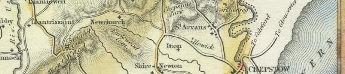

St Arvans
including Porthcasseg, St Lawrence & St Kingsmark
(A description written in 1891)
A Parish on the high road from Chepstow to Monmouth and Raglan, 2.1/2 miles north-west-by-north from Chepstow station, and comprising two Hamlets, PORTCASSEG and ST. LAWRENCE; there is also a farm, Rogerstone Grange, formerly ex-parochial; the parish is in the Southern division, Union and County Court district of Chepstow; eastern division of the rural deanery of Netherwent, Monmouth archdeaconry and Llandaff diocese.
The church of St. Arvan is an ancient building of stone, erected at various periods, and consisting of chancel, nave, north aisle and a tower containing one bell; the priest's door on the south side of the chancel is an interesting example of Early Norman work: the greater part was in 1883 rebuilt at a cost of about £2,000, of which the late Mrs. Clay, of Piercefield, subscribed one-fourth: a portion of the shaft of an ancient Saxon stone cross was found in taking down the walls of the nave; and in a cavity in the walls in another part of the church, a number of silver coins were discovered. The register dates from the year 1683, when all previous registers were burnt. The living is now a vicarage, annexed to Penterry in 1888, commuted tithe rent-charge £55, net yearly income £79, derived from 42 acres of glebe and Queen Ann's Bounty, in the gift of the Bishop and Duke of Beaufort, and held since 1883 by the Rev. John Tilley, of Schola Canellarii, Lincoln. The vicarage house was built in 1889 by public subscription and Queen Anne's Bounty. Parish Clerk: William Fisher; Assistant overseer: Martin Smith.
There is a Congregational chapel.
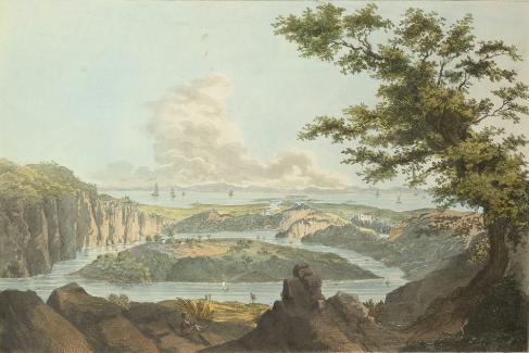 Piercefield Park, the seat of Henry Clay Esq. M.A., J.P. is about 400 acres in extent and is bounded on the east and north sides by beautifully wooded and precipitous cliffs, rising at the angle to a height of several hundred feet and commanding a fine view of the valley of the river Wye; the mansion is a handsome stone structure, built towards the close of the last century, by George Smith Esq., the then landowner, upon the site of an old mansion, which for many generations was the seat of the Walters family, by whom the estate had been sold in 1727.
PORTCASSEG
A Hamlet of St. Arvans, 3 miles north from Chepstow.
ST. LAWRENCE
A Hamlet 1 mile west from Chepstow. There were formerly churches in both the above hamlets and the site of that of St. Lawrence may still be distinctly traced.
At Rogerstone Grange are the remains of an old mansion, at one time occupied by the Curre family.
Schools:
National School, built in 1872, for 110 children; average attendance, 81; Edward B. Bendall, master; Miss Louisa Simmonds, mistress.
Post & M.O.O., S.B. & Annuity & Insurance Office: Martin Smith, receiver. Letters through Chepstow arrive at 6.50 a.m. & 4 p.m; dispatched at 4.15 & 7.10 p.m; Sundays, 11.30 a.m. The nearest telegraph office is at Chepstow.
The Duke of Beaufort K.G. is lord of the manor. The principal landowners are the Duke of Beaufort, Henry Clay and Walter Smedley Esqs., the Bishop of Llandaff, the Rectors of Itton and the Rev. John Henry Whiteley M.A., of St. Lawrence, Chepstow. The soil is loam and sand; subsoil, marl and limestone. The chief crops are wheat, barley and oats. The area is 2,214 acres of land; rateable value, £3,074.
The population in 1881 was 506.
……………
ST. KINGSMARK, or Kynemark,
A Parish, formerly extraparochial, 1 mile north-west from Chepstow railway station; in the Hundred of Caldicot, Union and County Court district of Chepstow, and, for Ecclesiastical purposes, included in the parish of St. Arvans.
Here was formerly a small Priory of ancient foundation, the history of which is unknown: some old stone walls yet remain to mark its site. There was also a church here, every vestige of which has disappeared.
The Duke of Beaufort is lord of the manor. The land belongs to Herbert Alexander Smith Esq. of The Mount, Chepstow, and is farmed by him. The area is 23 acres; rateable value, £92; the population in 1881 was 7.
Piercefield walks c.1780, engraving c.1802, courtesy of & © The British Library
(extracts from Kelly's 1891 Directory of Monmouthshire, transcribed by J. Doe)

Aberbargoed • Aberbeeg • Abercarn • Abergavenny • Abersychan • Abertillery (also see Aberystruth) • Aberystruth • Bettws (near Llantillio Pertholey) • Bettws (near Newport) • Bettws Newydd • Bishton • Blackwood • Blaenavon • Blaina • Briery Hill • Bryngwyn • Bwlch Trewyn • Caerleon or Llangattock-Juxta-Caerleon (see Christchurch for Caerleon Village) • Caerwent • Caldicot • Castleton • Cefnycrib • Chapel Hill • Chepstow • Christchurch (also see Newport) • Clawrplwyf • Coedkernew • Coed y Paen • Crick • Croesyceiliog • Cross Ash • Cross Keys • Crosshands • Crumlin (also see Llanhilleth & Mynyddislwyn) • Cwm (also see Ebbw Vale) • Cwmavon (also see Trevethin) • Cwmbran (also see Llanvihangel Llantarnam & Llanfrechfa) • Cwmcarn • Cwmcarvan • Cwmffrwdoer • Cwmnantddu • Cwmtillery (also see Aberystruth) • Cwmynyscoy • Cwmyoy • Devauden • Dewstow • Dingestow • Dinham • Dixton Newton • Duffryn • Earlswood • Ebbw Vale • Fleur-de-Lys • Freehold • Garndiffaith (also see Trevethin) • Garndyrris • Garnfach • Gellygroes • Glascoed • Goldcliff • Golynos • Govilon • Goytre • Graig • Griffithstown (also see Llanfrechfa & Panteg) • Grosmont • Gwehelog • Gwernesney • Hardwick • Henllys • High Cross • Highmoor Hill • Howick • Ifton • Itton • Kemeys Commander • Kemeys Inferior • Kilgwrrwg • Langstone • Little Mill • Llanarth • Llanbadoc • Llanbedr • Llandavenny • Llandewi Fach • Llanddewi Rhydderch • Llanddewi Skirrid • Llandegveth • Llandenny • Llandevaud • Llandogo • Llanellen • Llanfaeneor • Llanfair Discoed • Llanfair Gilgoed • Llanfair Kilgeddin • Llanfihangel Crucorney • Llanfihangel Gobion • Llanfihangel juxta Roggiett • Llanfihangel Llantarnam • Llanfihangel nigh Usk • Llanfihangel Pont y Moile • Llanfihangel Tafernbach • Llanfihangel Tor y Mynydd • Llanfihangel Ystern Llewern • Llanfihangel y Vedw • Llanfoist • Llanfrechfa • Llangattock • Lingoed • Llangattock nigh Usk • Llangattock Vibon Avel • Llangeview • Llangibby • Llangoven • Llangua • Llangwm Ishaf & Llangwm Uchaf • Llanhennock • Llanhilleth • Llanishen • Llanllowell • Llanmartin • Llanover • Llanrumney • Llansantffraed • Llansoy • Llanthewy Rytherch • Llanthewy Skirrid • Llanthewy Vach • Llanthomas • Llanthony • Llantillio Crossenny • Llantillio Pertholey • Llantrissent • Llanvaches • Llanvair Discoed • Llanvair Kilgeddin • Llanvapley • Llanvetherine • Llanwenarth Citra • Llanwenarth Ultra • Llanwern • Lliswerry • Llwyndu • Machen (Upper & Lower) • Maes-y-cwmmer • Magor • Maindee (also see Christchurch & Newport) • Malpas • Mamhilad • Marshfield • Mathern (also see St Pierre) • May Hill • Michaelston y Fedw • Mitchel Troy • Monkswood • Monmouth • Mounton • Mynyddbach • Mynyddislwyn • Mynyddmaen • Nantyderry • Nantyglo • Nash • New Town • New Tredegar • Newbridge • Newcastle • Newchurch East & West • Newport • Nightingale Village • Oldcastle • Overmonnow • Panteg • Par Grace Dieu • Pen y Clawdd • Penalt • Penbiddle • Pengam • Penhow • Penmaen • Penpergwm • Penrhos • Penrose • Penterry • Pentrepeod • Penygarn • Penyrheol • Peterstone Wentloog • Pillgwenlly • Ponthir • Pontllanfraith • Pontnewydd (also see Llanfrechfa) • Pontnewynydd • Pontrhydyryn • Pontygof • Pontymister • Pontymoile • Pontypool • Pontywain • Porthcasseg • Portskewett • Pwll Du • Pwllmeyric • Raglan • Redbrook • Redwick • Rhydgwern • Rhymney • Risca • Rock • Rockfield • Rogerstone • Roggiett • Rumney • Runston (also see Mathern) • St Arvans • St Brides Netherwent • St Brides Wentloog • St Kingsmark • St Lawrence • St Maughans • St Mellons • St Pierre (also see Mathern) • St Woolos • Sebastopol (also see Panteg) • Shirenewton • Sirhowy • Six Bells • Skenfrith • Snatchwood • Somerton Common • Sudbrook • Talywain (also see Trevethin) • The Race and Upper Race • Tintern Abbey • Tintern Parva • Tranch • Tredegar • Tredunnock • Tregare • Trellech • Trellech Grange • Trevethin • Treworgan • Trostrey • Undy • Upper Machen • Usk • Varteg • Victoria • Waunlwyd • Whitebrook • Whitson • Wilcrick • Wolvesnewton • Wonastow • Wyesham • Ynysddu
All images unless otherwise credited are © MonGenes and may not be reproduced without permission
© MonGenes 2013