
![]()
![]()

Newchurch East & West including Devauden
(A description written in 1891)
Together form a Parish anciently known as "Eglwys-newydd-ar-y-Cefn" and now include the Chapelry of DEVAUDEN; in the Southern division of the County, Upper division of the Hundred of Caldicot, Petty Sessional division and Union of Chepstow; eastern division of Netherwent rural deanery, Monmouth archdeaconry and Llandaff diocese.
East Newchurch is in the County Court district of Chepstow, and West Newchurch in that of Usk.
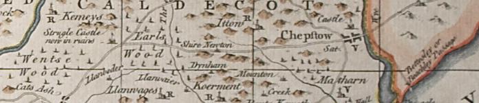
The Parish, which is intersected by the road from Chepstow to Usk, 6.1/2 miles north-west from the former town and 7.1/2 miles from Usk.
The church, occupying a bleak elevation on the northern side of the parish, is a building of stone, repaired in 1865: it is in the Early English style, and consists of chancel, nave, south porch and a western tower containing one bell: the Decorated east window is stained: the church has been thoroughly modernized but presents no features of interest: there are 100 sittings. The register of Baptisms and Burials dates from the year 1710; Marriages, 1755. The living is a vicarage, net yearly value £145, with two acres of glebe and residence, in the gift of the Duke of Beaufort, and held since 1882 by the Rev. Joseph Frederick Jones.
The Chapel of Ease in Devauden is a plain building with a belfry containing one bell and has an endowment of £32 yearly, which is in the gift of and at present held by the vicar of Newchurch.
There are chapels for Wesleyan Methodists at Pen-y-Cae-Mawr, at the Glyn, at Devauden; and for the Welsh Methodists at Gaerlwyd.
Post Office: Mrs. Alice E. Light, receiver. Letters through Chepstow, arrive at 9.15 a.m; dispatched 5.50 p.m. Shirenewton is the nearest money order office & nearest telegraph office at Chepstow. Wall letter box at Newchurch West cleared at 4.45 p.m.
Schools:
A School Board of 5 members was formed in 1874 for the United districts of East & West Newchurch, Kilgwrrwg & Wolvesnewton
Clerk to the Board & Attendance officer: Thomas Williams, Newchurch West
Board School, Devauden Green, rebuilt with house for master in 1879, at a cost of about £500, for 100 children; average attendance, 50; Thomas James, master.
The endowment of the former schools is now applied to purposes connected with the present schools: both the Chapel and former Endowed Schools were first established mainly through the exertions of James Davies, then village school-master, the story of whose untiring zeal in the cause of religion & education has been more than once published.
DEVAUDEN
(anciently Ddefawdon), two miles north-east from the parish church [of Newchurch], is said to have been the place where the Britons were overwhelmed and utterly defeated by the combined forces of the Saxon monarchs, Ethelbald of Mercia and Cuthred of Wessex, in 743. Various Roman coins of Antoninus and others were found at Devauden Green in 1840. There is a fine cromlech at Gaer-llwd.
In this parish there is a very extensive British camp, known as Gaer-Fawr - the great fortification - occupying a position of great natural strength upon the spur of a hill: the camp has an outer and inner vallum of stones and earth and extends over nearly twenty acres.
Chepstow Park, a wood of about 3,000 acres, is near here, in which is a reservoir for the Chepstow Waterworks. A considerable portion of the extensive wooded district, a;; that now remains of the extensive Forest of Wentwood, is in Newchurch West and here are the ruins of the Castle of Troggy, or Cas Troggy, so called from the rivulet of that name, which has its source near the castle. The ascription of the name of Strigul by Camden and some other writers to this castle has doubtless arisen from a corruption of the name Cas Troggy or Stroggy, and has given much confusion between this place and the real Strigul or Chepstow. Troggy Castle is said to have been built in the reign of Edward I. by Roger Bigod, Earl of Norfolk.
The Duke of Beaufort K.G. is lord of the manor, impropriator and principal landowner. The soil is loam and sand; subsoil, gravel and sandstone grit. The chief crops are grain and roots.
The area is:
Newchurch East, 3,212A. 0R. 10P. - rateable value, £2,088;
The population in 1881 was 389;
Newchurch West, 2,258A. 1R. 3P. - rateable value, £1,003;
The population in 1881 was 124
(extracts from Kelly's 1891 Directory of Monmouthshire, transcribed by J. Doe)

Aberbargoed • Aberbeeg • Abercarn • Abergavenny • Abersychan • Abertillery (also see Aberystruth) • Aberystruth • Basseleg • Bettws (near Llantillio Pertholey) • Bettws (near Newport) • Bettws Newydd • Bishton • Blackwood • Blaenavon • Blaina • Briery Hill • Bryngwyn • Bwlch Trewyn • Caerleon or Llangattock-Juxta-Caerleon (see Christchurch for Caerleon Village) • Caerwent • Caldicot • Castleton • Cefnycrib • Chapel Hill • Chepstow • Christchurch (also see Newport) • Clawrplwyf • Coedkernew • Coed y Paen • Crick • Croesyceiliog • Cross Ash • Cross Keys • Crosshands • Crumlin (also see Llanhilleth & Mynyddislwyn) • Cwm (also see Ebbw Vale) • Cwmavon (also see Trevethin) • Cwmbran (also see Llanvihangel Llantarnam & Llanfrechfa) • Cwmcarn • Cwmcarvan • Cwmffrwdoer • Cwmnantddu • Cwmtillery (also see Aberystruth) • Cwmynyscoy • Cwmyoy • Devauden • Dewstow • Dingestow • Dinham • Dixton Newton • Duffryn • Earlswood • Ebbw Vale • Fleur-de-Lys • Freehold • Garndiffaith (also see Trevethin) • Garndyrris • Garnfach • Gellygroes • Glascoed • Goldcliff • Golynos • Govilon • Goytre • Graig • Griffithstown (also see Llanfrechfa & Panteg) • Grosmont • Gwehelog • Gwernesney • Hardwick • Henllys • High Cross • Highmoor Hill • Howick • Ifton • Itton • Kemeys Commander • Kemeys Inferior • Kilgwrrwg • Langstone • Little Mill • Llanarth • Llanbadoc • Llanbedr • Llandavenny • Llandewi Fach • Llanddewi Rhydderch • Llanddewi Skirrid • Llandegveth • Llandenny • Llandevaud • Llandogo • Llanellen • Llanfaeneor • Llanfair Discoed • Llanfair Gilgoed • Llanfair Kilgeddin • Llanfihangel Crucorney • Llanfihangel Gobion • Llanfihangel juxta Roggiett • Llanfihangel Llantarnam • Llanfihangel nigh Usk • Llanfihangel Pont y Moile • Llanfihangel Tafernbach • Llanfihangel Tor y Mynydd • Llanfihangel Ystern Llewern • Llanfihangel y Vedw • Llanfoist • Llanfrechfa • Llangattock • Lingoed • Llangattock nigh Usk • Llangattock Vibon Avel • Llangeview • Llangibby • Llangoven • Llangua • Llangwm Ishaf & Llangwm Uchaf • Llanhennock • Llanhilleth • Llanishen • Llanllowell • Llanmartin • Llanover • Llanrumney • Llansantffraed • Llansoy • Llanthewy Rytherch • Llanthewy Skirrid • Llanthewy Vach • Llanthomas • Llanthony • Llantillio Crossenny • Llantillio Pertholey • Llantrissent • Llanvaches • Llanvair Discoed • Llanvair Kilgeddin • Llanvapley • Llanvetherine • Llanwenarth Citra • Llanwenarth Ultra • Llanwern • Lliswerry • Llwyndu • Machen (Upper & Lower) • Maes-y-cwmmer • Magor • Maindee (also see Christchurch & Newport) • Malpas • Mamhilad • Marshfield • Mathern (also see St Pierre) • May Hill • Michaelston y Fedw • Mitchel Troy • Monkswood • Monmouth • Mounton • Mynyddbach • Mynyddislwyn • Mynyddmaen • Nantyderry • Nantyglo • Nash • New Town • New Tredegar • Newbridge • Newcastle • Newchurch East & West • Newport • Nightingale Village • Oldcastle • Overmonnow • Panteg • Par Grace Dieu • Pen y Clawdd • Penalt • Penbiddle • Pengam • Penhow • Penmaen • Penpergwm • Penrhos • Penrose • Penterry • Pentrepeod • Penygarn • Penyrheol • Peterstone Wentloog • Pillgwenlly • Ponthir • Pontllanfraith • Pontnewydd (also see Llanfrechfa) • Pontnewynydd • Pontrhydyryn • Pontygof • Pontymister • Pontymoile • Pontypool • Pontywain • Porthcasseg • Portskewett • Pwll Du • Pwllmeyric • Raglan • Redbrook • Redwick • Rhydgwern • Rhymney • Risca • Rock • Rockfield • Rogerstone • Roggiett • Rumney • Runston (also see Mathern) • St Arvans • St Brides Netherwent • St Brides Wentloog • St Kingsmark • St Lawrence • St Maughans • St Mellons • St Pierre (also see Mathern) • St Woolos • Sebastopol (also see Panteg) • Shirenewton • Sirhowy • Six Bells • Skenfrith • Snatchwood • Somerton Common • Sudbrook • Talywain (also see Trevethin) • The Race and Upper Race • Tintern Abbey • Tintern Parva • Tranch • Tredegar • Tredunnock • Tregare • Trellech • Trellech Grange • Trevethin • Treworgan • Trostrey • Undy • Upper Machen • Usk • Varteg • Victoria • Waunlwyd • Whitebrook • Whitson • Wilcrick • Wolvesnewton • Wonastow • Wyesham • Ynysddu
All images unless otherwise credited are © MonGenes and may not be reproduced without permission
© MonGenes 2013