
![]()
![]()

Roggiett
(A description written in 1891)
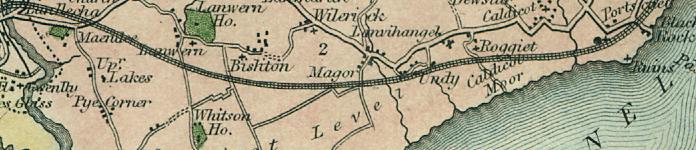
A Parish on the shore of the Bristol Channel, 7.1/2 miles south-west from Chepstow, 2.1/2 east from Magor station, 4 west from Portskewett station on the Great Western (South Wales) railway and 135 from London, the Severn Tunnel Junction is within this parish; in the Southern division of the county, Hundred of Caldicot, Petty Sessional division, Union and County Court district of Chepstow; middle division of the rural deanery of Netherwent, Monmouth archdeaconry and Llandaff diocese.
The church is an ancient building of stone presenting several features of interest, consisting of an unusually large chancel, nave, north porch and a western tower with a peculiar octagonal pinnacle at one corner, and containing one bell: a considerable portion of the fabric belongs to the Decorated period, but there are traces of Early English work: there is a curious old font: the church has 70 sittings, The register dates from the year 1750. The living is a rectory, with the rectories of Ifton and Llanfihangel [juxta-Roggiett] annexed, £65 yearly tithe rent-charge, gross yearly income £385 with 106A.1R. 8P. of glebe land, in the gift of Lord Tredegar, and held since 1878 by the Rev. Alfred George Morris B.A. of Jesus College, Oxford, who resides at Ifton, Parish Clerk: Edward Edwards.
Schools:
National School, built in 1887, for 100 children; average attendance, 30; Miss Annie Watkins, mistress.
Post: Letters through Chepstow arrive at 10 a.m. The nearest money order & telegraph office is at Caldicot. Wall letter box cleared at 5.10 p.m.
Railway Station:
Severn Tunnel Junction - James Henry Wootton, station master.
A Fair for cattle sheep and pigs is held here every first and third Tuesday in the month.
Lord Tredegar is lord of the manor and principal landowner. The soil is sandy loam; pasture and moor land is clay, but very good, and some peat; subsoil, various - limestone on the upper part. The chief crops are corn and there is much pasture land and considerable woods. The area is 550 acres of land and 2,355 of water; rateable value, £3,064.
The population in 1881 was 52.
(extracts from Kelly's 1891 Directory of Monmouthshire, transcribed by J. Doe)

Aberbargoed • Aberbeeg • Abercarn • Abergavenny • Abersychan • Abertillery (also see Aberystruth) • Aberystruth • Bettws (near Llantillio Pertholey) • Bettws (near Newport) • Bettws Newydd • Bishton • Blackwood • Blaenavon • Blaina • Briery Hill • Bryngwyn • Bwlch Trewyn • Caerleon or Llangattock-Juxta-Caerleon (see Christchurch for Caerleon Village) • Caerwent • Caldicot • Castleton • Cefnycrib • Chapel Hill • Chepstow • Christchurch (also see Newport) • Clawrplwyf • Coedkernew • Coed y Paen • Crick • Croesyceiliog • Cross Ash • Cross Keys • Crosshands • Crumlin (also see Llanhilleth & Mynyddislwyn) • Cwm (also see Ebbw Vale) • Cwmavon (also see Trevethin) • Cwmbran (also see Llanvihangel Llantarnam & Llanfrechfa) • Cwmcarn • Cwmcarvan • Cwmffrwdoer • Cwmnantddu • Cwmtillery (also see Aberystruth) • Cwmynyscoy • Cwmyoy • Devauden • Dewstow • Dingestow • Dinham • Dixton Newton • Duffryn • Earlswood • Ebbw Vale • Fleur-de-Lys • Freehold • Garndiffaith (also see Trevethin) • Garndyrris • Garnfach • Gellygroes • Glascoed • Goldcliff • Golynos • Govilon • Goytre • Graig • Griffithstown (also see Llanfrechfa & Panteg) • Grosmont • Gwehelog • Gwernesney • Hardwick • Henllys • High Cross • Highmoor Hill • Howick • Ifton • Itton • Kemeys Commander • Kemeys Inferior • Kilgwrrwg • Langstone • Little Mill • Llanarth • Llanbadoc • Llanbedr • Llandavenny • Llandewi Fach • Llanddewi Rhydderch • Llanddewi Skirrid • Llandegveth • Llandenny • Llandevaud • Llandogo • Llanellen • Llanfaeneor • Llanfair Discoed • Llanfair Gilgoed • Llanfair Kilgeddin • Llanfihangel Crucorney • Llanfihangel Gobion • Llanfihangel juxta Roggiett • Llanfihangel Llantarnam • Llanfihangel nigh Usk • Llanfihangel Pont y Moile • Llanfihangel Tafernbach • Llanfihangel Tor y Mynydd • Llanfihangel Ystern Llewern • Llanfihangel y Vedw • Llanfoist • Llanfrechfa • Llangattock • Lingoed • Llangattock nigh Usk • Llangattock Vibon Avel • Llangeview • Llangibby • Llangoven • Llangua • Llangwm Ishaf & Llangwm Uchaf • Llanhennock • Llanhilleth • Llanishen • Llanllowell • Llanmartin • Llanover • Llanrumney • Llansantffraed • Llansoy • Llanthewy Rytherch • Llanthewy Skirrid • Llanthewy Vach • Llanthomas • Llanthony • Llantillio Crossenny • Llantillio Pertholey • Llantrissent • Llanvaches • Llanvair Discoed • Llanvair Kilgeddin • Llanvapley • Llanvetherine • Llanwenarth Citra • Llanwenarth Ultra • Llanwern • Lliswerry • Llwyndu • Machen (Upper & Lower) • Maes-y-cwmmer • Magor • Maindee (also see Christchurch & Newport) • Malpas • Mamhilad • Marshfield • Mathern (also see St Pierre) • May Hill • Michaelston y Fedw • Mitchel Troy • Monkswood • Monmouth • Mounton • Mynyddbach • Mynyddislwyn • Mynyddmaen • Nantyderry • Nantyglo • Nash • New Town • New Tredegar • Newbridge • Newcastle • Newchurch East & West • Newport • Nightingale Village • Oldcastle • Overmonnow • Panteg • Par Grace Dieu • Pen y Clawdd • Penalt • Penbiddle • Pengam • Penhow • Penmaen • Penpergwm • Penrhos • Penrose • Penterry • Pentrepeod • Penygarn • Penyrheol • Peterstone Wentloog • Pillgwenlly • Ponthir • Pontllanfraith • Pontnewydd (also see Llanfrechfa) • Pontnewynydd • Pontrhydyryn • Pontygof • Pontymister • Pontymoile • Pontypool • Pontywain • Porthcasseg • Portskewett • Pwll Du • Pwllmeyric • Raglan • Redbrook • Redwick • Rhydgwern • Rhymney • Risca • Rock • Rockfield • Rogerstone • Roggiett • Rumney • Runston (also see Mathern) • St Arvans • St Brides Netherwent • St Brides Wentloog • St Kingsmark • St Lawrence • St Maughans • St Mellons • St Pierre (also see Mathern) • St Woolos • Sebastopol (also see Panteg) • Shirenewton • Sirhowy • Six Bells • Skenfrith • Snatchwood • Somerton Common • Sudbrook • Talywain (also see Trevethin) • The Race and Upper Race • Tintern Abbey • Tintern Parva • Tranch • Tredegar • Tredunnock • Tregare • Trellech • Trellech Grange • Trevethin • Treworgan • Trostrey • Undy • Upper Machen • Usk • Varteg • Victoria • Waunlwyd • Whitebrook • Whitson • Wilcrick • Wolvesnewton • Wonastow • Wyesham • Ynysddu
All images unless otherwise credited are © MonGenes and may not be reproduced without permission
© MonGenes 2013